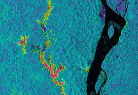
UAVSAR image data over Professor McDonald’s Napo River in Ecuador and Peru study areas, showing flooding beneath the forest canopy (by color intensity.) [Credit: NASA/JPL-Caltech]
CCNY professor heads projects imaging rivers, swamps and vineyards
An aircraft-mounted, multipurpose NASA radar system has just returned loaded with data from a month-long trek over rainforests, plateaus, swamps and fault lines of South America. This forms part of an ambitious mission to study wetlands, agriculture, climate and biogeography across broad swaths of the United States and nine other countries pairing high-resolution radar imaging with ground data.
Among the researchers leading investigations tied to the NASA mission is Dr. Kyle McDonald, City College of New York professor of earth and atmospheric sciences. Professor McDonald, who is a NASA Jet Propulsion Laboratory (JPL) researcher as well as an investigator with CCNY-based NOAA-CREST Center, led four data collection efforts to South America over places like the Pacaya-Samiria, one of the most extensively protected flooded forest areas in Peru.
“Pacaya-Samiria contains large expanses of flooded palm swamps,” said Professor McDonald. “These ecosystems are potential major sources of atmospheric methane, an important greenhouse gas.” The data will help piece together how methane from these unique swamp ecosystems interacts with Earth’s climate.
A C-20A aircraft flew the mission with NASA’s Uninhabited Aerial Vehicle Synthetic Aperture Radar (UAVSAR) slung beneath it. Taking off from California on March 7, the plane conducted airborne studies over Ecuador, Peru, and Chile for Professor McDonald’s projects, and flew over Guatemala, El Salvador, Nicaragua, Costa Rica, Colombia, Bolivia, Argentina, Arizona, New Orleans and the Mississippi River Delta.
NASA’s Jet Propulsion Laboratory in Pasadena, Calif., which manages its operations, built the UAVSAR system. UAVSAR uses a technique called interferometry, which sends pulses of microwave energy from a sensor on the aircraft to the ground to detect and measure subtle surface deformations, such as those caused by earthquakes, volcanoes, landslides and glacier movements.
Besides the Pacaya-Samiria National Reserve, another of Professor McDonald’s studies will use UAVSAR radar images of flooded areas of vegetation along the Napo River in Ecuador. Matching these images to inundation measurements taken on the ground by McDonald’s collaborator, Professor Stephen Hamilton of Michigan State University, gives them a key to interpret the extent of flooding by radar imagery alone for other areas. These results will help Professor McDonald map wetlands across the greater Amazon River basin for comparison with archived satellite radar data - another of Professor McDonald’s studies on this mission.
A third effort involved imaging the agricultural lands of Chile’s wine country to map soil moisture in Chile’s vineyards. The data will help assess the agricultural health and productivity of the land and allow future NASA missions to accurately map moisture across large land areas from Earth orbit. These studies were conducted in collaboration with Hector Castillo of the Universidad de La Serena-Chile and Vanessa Escobar of NASA’s Goddard Space Flight Center.
Professor McDonald’s fourth study examined the biodiversity and ecology of the Madre de Dios forest region of Peru. The data will help map the geological formations that underlie the Amazonian highlands, or planalto, to connect these to the current distribution of plants and how these were changed by geologic processes through deep time. “The goal of this particular project is to understand the evolutionary processes that gave rise to the biodiversity of the Amazon basin,” explained Professor McDonald.
Still other studies by other researchers will map sinking land areas in Arizona and the Gulf Coast, and monitor levees in Louisiana and Mississippi for leaks.
“This campaign highlights UAVSAR’s versatility for Earth studies,” said Naiara Pinto, UAVSAR science coordinator at JPL. “In many cases, study sites are being used by multiple investigators – for example, some volcanic sites also have glaciers. The studies are also helping U.S. researchers establish and broaden scientific collaborations with Latin America.”
On the Internet:
- UAVSAR
- Kyle McDonald
MEDIA CONTACT
Jessa Netting
p: 212.650.5310