Spring 2019. Subject to refinement/updating.
Instructor: Peter Matt
Schedule: Thursday 5:00 pm – 7:30 pm
Location: Marshak 107
3 credits 3 hrs/week
Instructor
Peter Matt
Department of Earth and Atmospheric Sciences, City College of New York
160 Convent Avenue, Marshak 717, New York, NY 10031
Telephone (212) 650-6984 Email: by request
Description
This course represents a comprehensive attempt to introduce students to major aspects of the multifaceted GIS production process, including data acquisition, editing, modeling, analysis, and cartographic output. EAS 330 is designed for students of the Earth and atmospheric sciences, as well as other disciplines. Lectures will introduce the theory and science behind Geographic Information Systems. Laboratory exercises will complement the lectures by introducing respective applications within the GIS software environment.
Objectives
- Demonstrate a solid, working knowledge of primary GIS skills.
- Define key geographic concepts, GIS terminology, components of a GIS, and GIS applications.
- Articulate an understanding of GIS processes, data sources, collection, and input, to methods of database management, analysis, and outputs for effective cartography.
- Demonstrate the use of GIS in hydrogeology, environmental management, emergency response practices in response to natural hazards, and understand the career options available to GIS analysts.
During the last few decades, earth scientists and geographers have begun to collect together huge files of locally collected data into massive data bases so that they can analyze global phenomena. Only with large amounts of detailed data collected over large areas can new global models be developed. An example of global modeling creating new correlations and interpretations not possible with only regional data is climate modeling. No one thought that an obscure local change documented by Peruvian and Ecuadorian fishermen who were concerned with cyclical decreases and increases in the volume of fish (which they called El Nino), could connect with periodic excessive heating in the equatorial Pacific thousands of kilometers away. El Nino has more recently been shown to correlate with periods of increased drought in the SW US and with increased rainfall in the NE. Only after the observed coeval events were documented into massive databases could new climate models be developed.
Applications will include: flood patterns in New Orleans vis a vis toxic waste sites, habitat analysis of Western endangered species, ecological problems with invasive thistle, snail, or gypsy moth species, site planning of a dam and railway, analyzing changes in vegetation patterns, site planning on different slopes and sun-angles for solar energy, deforestation patterns, hurricane tracking, earthquake hazards analysis, locating artesian wells, etc.
Reading
In addition to the required texts, which are discussed below, realistic geographic, environmental, and geologic problems will be used in the class and take-home assignments.
The required text is: Getting to Know ArcGIS Desktop (GTK) by Ormsby, et al. published by ESRI Press. It should come with version 10.x You need GTK because it comes with a 6-month fully functional ArcGIS program with optional Extensions which you can install on your home computer or laptop, the main programs with some of the spatial and statistical programs are worth $4000. The book is a fast read and has simple examples and a good index, plus tutorials and examples. The book is available new and used on Amazon and B&N. If you purchase a used copy, make sure it says it comes with an unused or sealed CD.
All students should bring in a flash drive and save their work frequently. Crashes do occur. If you save the datafiles, too, you will be able to practice the skills outside of class.
Course Requirements
This is a general introduction to GIS. There are 13 lab-based sessions. Most sessions will have a 10 minute introductory lecture, followed by a demonstration. The second half of each session will be an in-class assignment on the computer.
Required Materials
A USB flash drive is required for this course. It should be at least 8 GB (preferred). Prices can vary and this item is available from your bookstore, but is cheaper at other stores. You are required to have your USB drive by the beginning of week 2.
Email Policy
The instructor reserves the right to not answer email communications that do not meet the following criteria:
- The student last name and course number must appear in the email subject line
- Messages need to be signed with the full student name, department and major information
- Spell-check your messages and avoid language abbreviations common in online chatting and text messaging
- Use your CCNY email account in all communications.
Classroom Etiquette
Every few years the behavior of several students compels me to remind the whole class of what may seem obvious to most:
a) Talking during lecture is inconsiderate and disconcerting to me as well as to those trying to listen, think, and take notes.
b) It is rude to walk in front of class (between the lecturer and the class) after class has begun. If you come in late quietly take a seat in the back of the room.
Attendance
This is a hands-on course using computer ArcGIS software. Attendance and promptness are essential. The assignments and continued experimentation will build rapid facility and mastery. As with all computer-based courses, missed classes will result in falling far behind the class.
Accommodations for Students with Disabilities
The AccessAbility Center (AAC) facilitates equal access and coordinates reasonable accommodations and support services for City College students with disabilities. Visit: http://www.ccny.cuny.edu/accessability/ for more information.
Academic Integrity
Academic integrity governs all aspects of academic work. Academic dishonesty is prohibited in the City University of New York, and is punishable by failing grades, suspension and expulsion. If a violation should arise, it will be reported for appropriate action. For more information, visit https://www.ccny.cuny.edu/about/integrity. Please read the summary below of “What behaviors constitute academic dishonesty?” (shared by Professor Peter Bower, Senior Lecturer, Barnard College, Columbia University – abridged here).
- Cheating on examinations, quizzes, tests, or other assignments
- Plagiarism
- Submission of the same work for more than one course
- Falsification or misrepresentation of data in any coursework.
- Altering, defacing, or concealing library materials.
- Participating in the academic dishonesty of another student
- Misrepresentation of one’s state of health or personal situation
- Forgery of a signature
Grading
There are 12 in-class assignments. Before leaving the classroom, email the resulting maps as jpegs to the instructor (or post on Blackboard.) The file name will be the first THREE letters of your last name and the 1st letter of your first, plus assignment CODE as given on top of each assignment. An example might be winmafricamap1.jpeg. In class assignments are worth 60% of the grade.
If the assignment is too long, or if there are computer problems, the assignment may be completed at home. Take-home assignments will be due before the next class.
The overall grading for this course will be based on the following formula:
| Lab assignments (in-class) | 60% |
| Quizzes (two, in-class) (March 7, May 2) | 30% |
| Final project analyzing data using ArcGIS | 10% |
There is also a midterm exam on March 21 and a final exam on May 16.
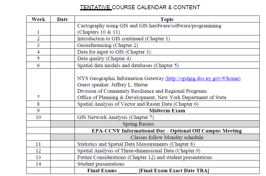
Course Outline
Last Updated: 01/29/2024 10:43